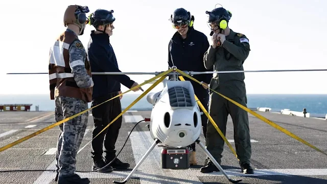
The name of the Austrian-made Schiebel Camcopter S-100 drone is already well-known for use by the navies of several countries, for example the S-100 which was once offered to the Indonesian Navy, is currently operated by the French, British and Australian navies.
Apart from being 'recalcitrant' for reconnaissance duties over the ocean, the S-100 can also be armed, such as being fitted with a Lightweight Multirole Missile (LMM). Well, there is new news from the Australian Navy regarding the use of the S-100.
In the "Exercise Sea Raider" military training event, the S-100, which was operated from the helicopter carrier - Landing Helicopter Dock (LHD) HMAS Adelaide, received a new task in reconnaissance. Specifically, the S-100 is fitted with a Light Detection and Ranging (LiDAR) sensor module as a payload.
By carrying LiDAR, this copter drone specifically plays a role in supporting the implementation of amphibious landing operations.
With LiDAR, the S-100 can perform bathymetric and littoral light detection before the amphibious landing exercise is carried out. Deployed from HMAS Adelaide, the drone projects a green wavelength laser through the ocean surface to map the topography of the seafloor and coast.
Reported by interestingengineering.com (22/8/2023), the effectiveness of this new model mapping technique was evaluated at different heights. The S-100 drone can fly several hundred kilometers in various weather conditions, day or night. This drone can also be integrated with systems on aircraft carriers to assist intelligence missions and air traffic control.
“[With the new technique] we create a survey plan for the landing area, then create 3D flight profiles and gradients, either electronically or on paper, which are used as a briefing tool about shallow water bathymetry, beaches, backshore topography,” said Lt. Colonel Thomas Lennards of the Australian Navy. "Surveys are used to navigate hazards, coastal entry and exit points, helicopter landing zones, bridges, inland areas and terrain," he added.
In addition to using the S-100 drone with LiDAR, the Australian Navy also has overlays of sea charts and satellite imagery which are used to ensure the most up-to-date information in our collection and compare anomalies with what is scanned, and against what is mapped.
Experts from the Australian Defense Science and Technology Group (DST) also tested a handheld 3D laser scanner on HMAS Adelaide for tactical applications, including battlefield damage assessment.
The technical specifications of the Schiebel S-100 drone, which have a main rotor diameter of 3400 mm, a total length of 3110 mm, a height of 1120 mm, a maximum T/O weight of 200 kilograms and an empty weight of 110 kilograms. The internal fuel tank is 57.1 liters and the external fuel tank reaches 25.4 liters.
This drone data link connection can reach a radius of 200 kilometers, this means LoS (Line of Sight) connections can be made up to that distance.
The S-100 can fly up to a maximum of 240 km per hour, a speed of 185 km per hour, and an operating speed of 100 km per hour. Endurance in the air of the Schiebel S-100 is six hours with a playload of 50 kilograms and an altitude limit of up to 5,500 meters.
From the drone pilot side, the manufacturer, namely Schiebel Elektronikche Gerate GmBH, completes the Ground Control Station (GCS) with a mission control screen that can provide realtime video information from the pilot's camera, including flight data displays as is common in modern aircraft.


